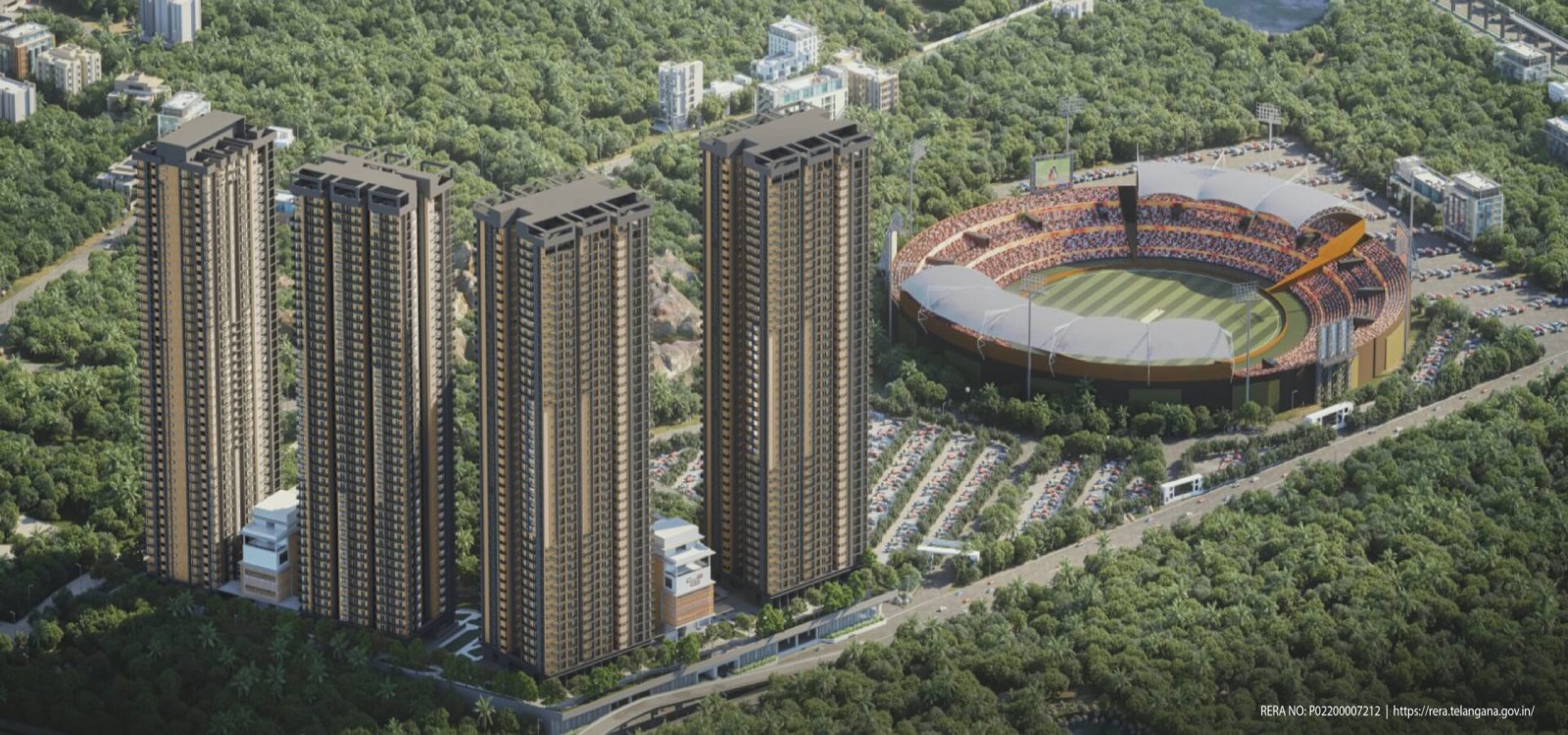
Uppal’s Metro, Rail & Regional Connectivity: The Complete Guide
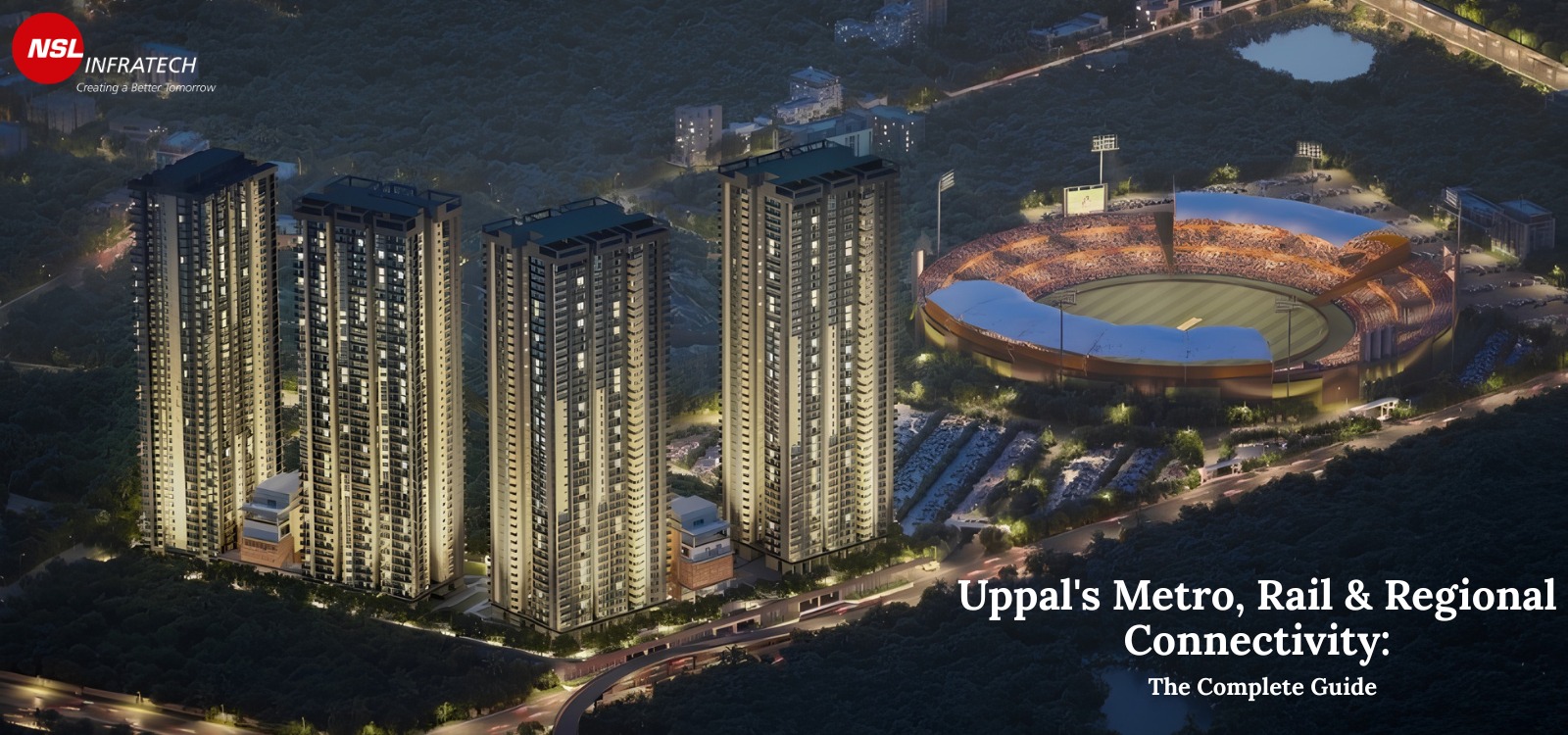
Uppal is no longer just a junction on the Warangal highway. It is quietly turning into one of the most well-connected corners of Hyderabad, thanks to a metro line that already works, a railway terminal being upgraded, and roads that will soon loop around the entire city.
Think of a city as a living body. Roads are like veins, and transport stations are like the heart, they push people, ideas, money, and energy to every corner. For decades, Uppal was on the eastern edge of Hyderabad, a bit cut off from the action happening in the west. The IT boom in Hitec City, the malls of Banjara Hills, the offices of Gachibowli, all of it felt far away if you lived or worked near Uppal.
This article is a deep dive into every layer of that connectivity, what exists today, what is under construction, and what is planned for the future. Whether you are a student, a homebuyer, a business owner, or simply someone curious about how cities are built, this guide will help you understand exactly what is happening and why it matters.
The Blue Line: Uppal’s Lifeline to the City
Let us start with what already exists and works right now: the Hyderabad Metro’s Blue Line. The Blue Line is one of the busiest corridors of the Hyderabad Metro Rail system. It runs from Nagole in the east all the way to Raidurg in the west, passing through Uppal along the way.
To understand what this means for someone living or working near Uppal, imagine you need to get to Hitec City — Hyderabad’s biggest IT hub, home to companies like Microsoft, Google, and dozens of Indian tech giants. Before the metro, this journey could take anywhere from 45 minutes to well over an hour by road, depending on traffic. By metro, you can now do it in roughly 35 to 40 minutes, sitting comfortably in an air-conditioned coach, without worrying about traffic jams.
The Uppal Metro Station is what planners call an “interchange station” — a station where multiple lines can eventually meet and passengers can switch between routes. This is extremely valuable. It means Uppal is not just a stop on one line, but a hub where future metro expansions can connect. Think of it like a railway junction in the old days: a town with a junction always grew faster than one with just a simple pass-through station.
Simple explanation
The Blue Line is like an express highway in the air. It connects Uppal to Nagole on one end and to major IT hubs like Hitec City and Raidurg on the other. For daily commuters, this means no more sitting in traffic to get to work.
The Airport Corridor: Coming Soon to a Station Near You
Now here is where things get very exciting for Uppal’s future. The Blue Line is planned to be extended from its current terminal points all the way to Rajiv Gandhi International Airport (RGIA) in Shamshabad. This extension, a massive 36.8-kilometre corridor, is part of the officially approved Phase 2 plan of the Hyderabad Metro.
Why does this matter for Uppal specifically? Because this extension will not be a separate, disconnected line. It will link up with the existing Blue Line, meaning passengers at Uppal Metro Station will be able to board a train and, after changing at an interchange, travel directly to the airport — without using a car, a cab, or an auto. For a city like Hyderabad, where the airport is a long distance from the eastern parts of the city, this is a huge deal.
“A metro link to the airport changes a neighbourhood’s entire economic character. It connects residents to global mobility.”
The 36.8 km corridor is not a small project. It requires tunnelling, elevated track construction, new stations, and coordination with airport authorities. These projects take time — years, not months. But the fact that it is approved under Phase 2 means it is not just a dream on paper. It is moving toward real execution, with land acquisition and planning processes already underway.
For students reading this: imagine what it means for a city’s property values and economic growth when a neighbourhood gets airport connectivity by metro. Cities around the world — from London to Singapore to Delhi — have seen massive development booms along their airport metro corridors. Uppal is positioned to benefit from exactly that kind of transformation.
Phase 3 Proposals: Bibi Nagar, ECIL, and Beyond
The story does not stop at the airport. Under the proposed Phase 3 expansions — which are still in the planning and approval stage — there are two additional metro lines that would originate or pass through Uppal.
The first proposed line would connect Uppal to Bibi Nagar, via Ghatkesar. This route runs along the Warangal highway corridor, one of Hyderabad’s most important east-west arterial roads. Ghatkesar and Bibi Nagar are emerging residential and commercial areas that have been growing rapidly. A metro connection along this route would serve thousands of daily commuters and also open up a huge stretch of land for development — because when metro comes, real estate and businesses follow.
The second Phase 3 proposal connects Uppal to ECIL Crossroads. ECIL (Electronics Corporation of India Limited) is a major landmark in north-eastern Hyderabad, with its own economic and residential character. A metro line between these two points would serve a densely populated corridor and provide a new north-south link that currently depends entirely on road transport.
Important note
Phase 3 proposals are still being planned and have not received final government approval as of early 2026. However, their inclusion in long-term transport plans signals serious intent and gives property investors and businesses a reason to look at Uppal as a long-term bet.
The Charlapalli Railway Terminal: A New Gateway for Eastern Hyderabad
Now let us shift from metro to mainline railways — a completely different system, but equally important for connectivity.
Hyderabad’s primary railway stations are Secunderabad and Hyderabad Deccan (Nampally). Both of these are old, congested, and located in the western and central parts of the city. Getting to these stations from Uppal means a long road journey through heavy traffic. For someone in the east of Hyderabad who needs to catch a train to Mumbai, Delhi, or Chennai, this has always been a major inconvenience.
The Charlapalli Railway Station is changing that. Located in the eastern part of Hyderabad, very close to Uppal, Charlapalli is being upgraded and developed into a world-class coaching terminal. A “coaching terminal” is a railway station that can originate and terminate long-distance trains — meaning trains can start and end their journeys here, not just pass through. This is a major upgrade from being just a small stop.
Why is this important? Because it means the eastern parts of Hyderabad — including Uppal, LB Nagar, Nacharam, and surrounding areas — will soon have direct train access to the rest of India without needing to travel across the city to Secunderabad. Families visiting relatives, business travellers, and students going to colleges in other cities will all benefit enormously from having a proper terminal nearby.
What is a coaching terminal?
In railway language, a “coaching terminal” is a station from where passenger trains originate and terminate. It is different from a passing halt where trains just stop briefly. Having a coaching terminal means Charlapalli can host entire trains with their own schedules — making it a real railway hub, not just a stoppage.
The Three Mega Terminals: India’s Railway Future
Beyond Charlapalli, Indian Railways has an even grander vision for Hyderabad’s region — one that will take 50 years to fully realise but whose foundations are being laid right now. This vision is called the Regional Ring Rail (RRR), and it involves three massive new railway terminals being built at different points around the outskirts of Hyderabad.
These are not regular stations. They are being planned to handle future railway traffic for the next half century — mega-infrastructure projects on a scale that is rare even in India’s history of big projects.
| Terminal | Location | Trains Served | Distinction |
| Nagalapalli | West of Hyderabad | Maharashtra & Karnataka directions | Planned as India’s third-largest railway station |
| Jukal | South Hyderabad (near Umdanagar) | South-bound routes | Major southern gateway terminal |
| Dabilpur | North Hyderabad | Nizamabad & Nanded directions | Northern hub for inbound traffic |
The Nagalapalli Terminal deserves special mention. It is being planned to become India’s third-largest railway station — a colossal facility that will handle trains heading towards Maharashtra (Mumbai, Pune) and Karnataka (Bengaluru). The scale of planning behind this project reflects how seriously the government is thinking about Hyderabad’s long-term future as a major metropolitan centre.
The Regional Ring Road: Hyderabad’s Giant Bypass
Now let us talk about roads — specifically the largest road project in the region: the Regional Ring Road (RRR). Not to be confused with the Regional Ring Rail mentioned above (yes, there are two “RRRs”), the Regional Ring Road is a 340-kilometre expressway that will encircle the entire Hyderabad Metropolitan Region.
Three hundred and forty kilometres is an enormous distance. To put that in perspective, it is roughly the distance from Hyderabad to Nagpur by road. This ring road is not a city bypass — it is a regional expressway that connects major national highways and creates a looped corridor around the whole metropolitan area.
The Musi Riverfront Road: An Alternate Route Through Green Spaces
The final piece of Uppal’s connectivity puzzle is the most interesting from an urban design perspective: a 16-kilometre radial road planned along the banks of the Musi River.
The Musi River flows near Uppal, and the state government’s Musi Riverfront Development project is a large-scale effort to clean up, beautify, and develop the riverbanks into usable public space — parks, walkways, and cultural areas. As part of this project, a radial road is planned along the river’s edge that would connect the Warangal highway (near Uppal) all the way to the ORR (Outer Ring Road).
Putting It All Together: What Uppal’s Connectivity Map Looks Like
Take a step back and look at everything together. You have a working metro line that already connects Uppal to western Hyderabad. You have an approved Phase 2 airport corridor extension. You have two Phase 3 metro proposals that would branch out from Uppal. You have a railway terminal nearby being upgraded to world-class status. You have three mega railway terminals being planned regionally. You have a 340-km ring road being built around the city. And you have a river-road project that will relieve the Uppal junction.
This is not one project. This is a coordinated, multi-layered transformation of an entire region’s infrastructure. The effect of all these projects arriving at roughly the same time — over the next 10 to 15 years — will be cumulative. Each layer of connectivity makes every other layer more valuable. A metro line to the airport is more useful if there is also a good road to the metro station. A railway terminal is more accessible if a ring road passes nearby. Urban infrastructure works like a network: the more connections you add, the more powerful every existing connection becomes.
Amid this rapidly evolving infrastructure landscape, projects like NSL East Luxoria, Uppal, Hyderabad stand out as prime residential opportunities. Strategically located to leverage these upcoming developments, it offers residents the advantage of seamless connectivity, strong future appreciation, and a well-balanced urban lifestyle.
- Now — Blue Line Operational
Uppal connected to Nagole–Raidurg corridor via the existing Hyderabad Metro Blue Line. - Near Term — Charlapalli Terminal Upgrade
Charlapalli being developed as a world-class coaching terminal, offering long-distance train access from East Hyderabad. - Phase 2 — Airport Metro Corridor
36.8 km Blue Line extension to RGIA Shamshabad airport; passengers from Uppal will gain seamless airport access via interchange. - Mid-Term — Regional Ring Road
340 km expressway encircling the Hyderabad Metropolitan Region; Uppal’s proximity enhances regional road access. - Long Term — Phase 3 Metro + Mega Rail Terminals
Uppal–Bibi Nagar–Ghatkesar line, Uppal–ECIL line proposed; three mega terminals at Nagalapalli, Jukal, Dabilpur planned for 50-year regional capacity.


Leave a comment
Be the first to comment